Great Circles and a Point
Overview
Oh no! A plane traveling across the country suddenly discovers it is low on fuel! It can no longer make it to the planned airport, instead it has to find the closest airport to its current position that it can make it with its remaining fuel.
In great circle terms, we want to determine how far a point (let’s say, the next closest airport) is from a great circle arc (the flight’s path). In this notebook we will:
Determine the distance of a point to a great circle arc (cross-track and along-track distance)
Determine if a point lies on a great circle arc and path (with and without tolerances)
Prerequisites
| Concepts | Importance | Notes |
|---|---|---|
| Numpy | Necessary | Used to work with large arrays |
| Pandas | Necessary | Used to read in and organize data (in particular dataframes) |
| Intro to Cartopy | Helpful | Will be used for adding maps to plotting |
| Matplotlib | Helpful | Will be used for plotting |
Time to learn: 40 minutes
Imports
Import Packages
Setup location dataframe with coordinates
import pandas as pd                                    # read in data text file
import numpy as np                                     # working with degrees and radians

from pyproj import Geod                                # working with the Earth as an ellipsod (WGS-84)
import geopy.distance                                  # moving along a known distance on the Earth's ellipsoid surface

import matplotlib.pyplot as plt                        # plotting a graph
from cartopy import crs as ccrs, feature as cfeature   # plotting a world map
# Get all Coordinates for Locations
location_df = pd.read_csv("../location_full_coords.txt")
location_df = location_df.rename(columns=lambda x: x.strip()) # strip excess white space from column names and values
location_df.index = location_df["name"]
location_df.head()Determine the distance of a point to a great circle arc
The distance from a point to a great circle arc is known as the cross track distance (sometimes known as cross track error). For example, how far would a plane have to fly from its path to get to an unscheduled airport for refueling? Meantime, the along track distance measures how far along the great arc a point lies. For instance, what is your new position (latitude/longitude) when you’ve traveled 250 km into your 2000 km plane ride?
Cross track distance: angular distance from point P to great circle path
Along track distance: angular distance along the great circle path from A to B before hitting a point that is closest to point P
geodesic = Geod(ellps="WGS84")
earth_radius = 6378137  # meters
Cross Track Distance
Distance of a point to a great circle arc is defined as:
Where,
δ13 (delta_13) is (angular) distance from start point to third point
θ13 (theta_13) is (initial) bearing from start point to third point
θ12 (theta_12) is (initial) bearing from start point to end point
R is the earth’s radius
Then,
Where,
Positive Cross-Track Distance: Point lies in the hemisphere to the left of the great circle
Negative Cross-Track Distance: Point lies in the hemiphere to the right of the great circle
Note: If the point A is the North or South Pole replace
crs_AD-crs_ABwithlon_D-lon_Borlon_B-lon_D, respectively
That was a lot of math, let’s see how that translates into a Python function. For the purpose of this example, let’s determine the forward bearing and distance between the great circle arc and the new point on an ellipsoid.
We will be creating two sides of a spherical triangle. Side 1 will be the great circle arc formed from Point A to Point B, while Side 2 will be a new great circle arc we will create from Point A to the new point C. We can use the angle—angular distance—between these two legs to determine the cross track distance:
def cross_track_distance(start_point=None, end_point=None, new_point=None):
    # Determine the forward bearing from Point A (start) to Point B (end)
    fwd_bearing_start_end, _, _ = geodesic.inv(location_df.loc[start_point, "longitude"],
                                               location_df.loc[start_point, "latitude"],
                                               location_df.loc[end_point, "longitude"],
                                               location_df.loc[end_point, "latitude"])

    # Determine the forward bearing (angle) and distance from Point A (start) to new Point C
    fwd_bearing_start_new, _, distance_m_start_new = geodesic.inv(location_df.loc[start_point, "longitude"],
                                                                  location_df.loc[start_point, "latitude"],
                                                                  location_df.loc[new_point, "longitude"],
                                                                  location_df.loc[new_point, "latitude"])

    # Determine the Angular Distance from Point A to Point C
    angular_distance_start_new = distance_m_start_new / earth_radius
    ct_distance = np.arcsin(np.sin(angular_distance_start_new) * np.sin(np.deg2rad(fwd_bearing_start_new - fwd_bearing_start_end))) * earth_radius
    return ct_distance
Along Track Distance
Imagine a great circle arc that will appear like: A -------- C -------------------B, where the distance along the great circle arc (created from Point A to B) from Point A to Point C is the along-track distance.
This is defined as:
δ13 (delta_13) is (angular) distance from start point to third point
δxt (delta_xt) is (angular) cross-track distance
R is the earth’s radius
So,
However, for very short distances we can also use a new equation that is less susceptible to rounding errors:
To similarly convert into a Python function, we will need to know the total length of the great circle arc from Point A to Point B. We will also measure the distance from the Point A to the new Point C along the great circle arc from Point A to Point B.
def along_track_distance(start_point=None, end_point=None, new_point=None):
    # Determine the cross track distance from Point A to Point B from Point C
    crosst_distance = cross_track_distance(start_point, end_point, new_point)

    # Determine the total distance of a great circle arc from Point A to Point C
    _, _, distance_m_start_new = geodesic.inv(location_df.loc[start_point, "longitude"],
                                              location_df.loc[start_point, "latitude"],
                                              location_df.loc[new_point, "longitude"],
                                              location_df.loc[new_point, "latitude"])

    # Determine the Along-Track Distance using the Cross Track Distance Distance
    angular_distance_start_new = distance_m_start_new / earth_radius
    at_distance = np.arccos(np.cos(angular_distance_start_new) / np.cos(crosst_distance / earth_radius)) * earth_radius
    return at_distance
Determine Closest Point along Great Circle Arc
To be able to plot a cross track distance we need to find the point on the great circle that is closest to the new Point C. To do this we need to find the closest point from Point C to the arc and measure the along track distance that the intersection lies
# Distance point along great circle path
def point_along_path(start_point=None, end_point=None, distance_m=None):
    fwd_bearing, _, _ = geodesic.inv(location_df.loc[start_point, "longitude"],
                                     location_df.loc[start_point, "latitude"],
                                     location_df.loc[end_point, "longitude"],
                                     location_df.loc[end_point, "latitude"])
    origin = geopy.Point(location_df.loc[start_point, "latitude"],
                         location_df.loc[start_point, "longitude"])
    distance_to_move = geopy.distance.distance(
                            kilometers=distance_m / 1000)  # distance to move towards the next point
    final_position = distance_to_move.destination(origin, bearing=fwd_bearing)
    return (final_position.latitude, final_position.longitude)
Let’s see how of this looks on a map! Let’s plot!
In the previous notebook, we determined how to interpolate points along the great circle arc (interpolate_points_along_gc and arc_points). We will repeat the functions below to be able to use them to plot the great circle arc with the new information about cross-track and along-track distances
# See Previous Notebook for how these functions were defined

def interpolate_points_along_gc(lat_start,
                                lon_start,
                                lat_end,
                                lon_end,
                                distance_between_points_meter):
    lat_lon_points = [(lat_start, lon_start)]

    # move to next point when distance between points is less than the equal distance
    move_to_next_point = True
    while(move_to_next_point):
        forward_bearing, reverse_bearing, distance_meters = geodesic.inv(lon_start,
                                                                         lat_start,
                                                                         lon_end,
                                                                         lat_end)
        if distance_meters < distance_between_points_meter:
            # ends before overshooting
            move_to_next_point = False
        else:
            start_point = geopy.Point(lat_start, lon_start)
            distance_to_move = geopy.distance.distance(
                            kilometers=distance_between_points_meter /
                            1000)  # distance to move towards the next point
            final_position = distance_to_move.destination(
                            start_point, bearing=forward_bearing)
            lat_lon_points.append((final_position.latitude, final_position.longitude))
            # new starting position is newly found end position
            lon_start, lat_start = final_position.longitude, final_position.latitude
    lat_lon_points.append((lat_end, lon_end))
    return lat_lon_points

def arc_points(start_lat=None,
               start_lon=None,
               end_lat=None,
               end_lon=None,
               n_total_points=10):
    _, _, distance_meter =  geodesic.inv(start_lon,
                                        start_lat,
                                        end_lon,
                                        end_lat)

    distance_between_points_meter = distance_meter / (n_total_points + 1)


    new_points_lst = interpolate_points_along_gc(start_lat,
                                              start_lon,
                                              end_lat,
                                              end_lon,
                                              distance_between_points_meter)
    return new_points_lst
To begin, we will plot the cross track distance. This will look like a map with two arcs: one from Point A to Point B (the primary great circle arc) and a second that will show the angular distance between the great circle arc and a new point
def plot_cross_track(start_point=None, end_point=None, new_point=None,
                     lon_west=-130, lon_east=-60,
                     lat_south=20, lat_north=60):
    # Set up world map plot
    fig = plt.subplots(figsize=(16, 10))
    projection_map = ccrs.PlateCarree()
    ax = plt.axes(projection=projection_map)
    ax.set_extent([lon_west, lon_east, lat_south, lat_north], crs=projection_map)
    ax.coastlines(color="black")
    ax.add_feature(cfeature.BORDERS, edgecolor='grey')
    ax.add_feature(cfeature.STATES, edgecolor="grey")

    # Cross-Track and Along-Track Distances
    ct_distance = cross_track_distance(start_point, end_point, new_point)
    print(f"Cross Track Distance: \n{ct_distance} meters ({ct_distance/1000} km)")

    at_distance = along_track_distance(start_point, end_point, new_point)
    print(f"Along Track Distance: \n{at_distance} meters ({at_distance/1000} km)\n")

    closest_point = point_along_path(start_point, end_point, at_distance)
    print(f"Closest Point To Point Along Great Circle Path:\n{closest_point}")

    # Plot Latitude/Longitude Points of the Great Circle Arc (with 10 interpolate points)
    great_circle_arc_pts = arc_points(location_df.loc[start_point, "latitude"],
                                      location_df.loc[start_point, "longitude"],
                                      location_df.loc[end_point, "latitude"],
                                      location_df.loc[end_point, "longitude"],
                                      10)
    longitudes = [x[1] for x in great_circle_arc_pts] # longitude
    latitudes = [x[0] for x in great_circle_arc_pts] # latitude
    plt.plot(longitudes, latitudes, c="purple")
    plt.scatter(longitudes, latitudes, c="purple")

    # Plot the Cross Track Distance as an Arc from Point C to the closest point on the arc (Point D) (with 10 intrpolated points)
    cross_track_arc = arc_points(closest_point[0],
                                 closest_point[1],
                                 location_df.loc[new_point, "latitude"],
                                 location_df.loc[new_point, "longitude"],
                                   10)
    longitudes = [x[1] for x in cross_track_arc] # longitude
    latitudes = [x[0] for x in cross_track_arc] # latitude
    plt.plot(longitudes, latitudes, c="green")
    plt.scatter(longitudes, latitudes, c="green")

    # Plot the Closest Point on the Arc in Red (to see easier)
    plt.scatter(closest_point[1], closest_point[0], c="red")

    plt.title(f"Closest Point {closest_point} from {start_point.title()}->{end_point.title()} to {new_point.title()}, Cross-Track Distance = {ct_distance/1000:4f} km")
    plt.show()
Positive Cross-Track Distance: Point lies in the hemisphere to the left of the great circle
Negative Cross-Track Distance: Point lies in the hemiphere to the right of the great circle
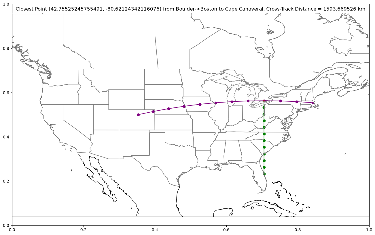
plot_cross_track(start_point="boulder", end_point="boston", new_point="cape canaveral")Cross Track Distance:
1593669.526094791 meters (1593.669526094791 km)
Along Track Distance:
2076501.5510165778 meters (2076.5015510165777 km)
Closest Point To Point Along Great Circle Path:
(42.75525245755491, -80.62124342116076)
/home/runner/micromamba/envs/cookbook-gc/lib/python3.14/site-packages/cartopy/io/__init__.py:242: DownloadWarning: Downloading: https://naturalearth.s3.amazonaws.com/50m_physical/ne_50m_coastline.zip
  warnings.warn(f'Downloading: {url}', DownloadWarning)
/home/runner/micromamba/envs/cookbook-gc/lib/python3.14/site-packages/cartopy/io/__init__.py:242: DownloadWarning: Downloading: https://naturalearth.s3.amazonaws.com/50m_cultural/ne_50m_admin_0_boundary_lines_land.zip
  warnings.warn(f'Downloading: {url}', DownloadWarning)
Determine if a point lies on a great circle arc and path
Does a given Point C lie on a great circle arc? Does it lie on the great circle path? We can check if a point lies on a great circle path/arc if:
Check if the latitude/longtiude matches the expected latitude that the same longitude position would have produced on the great circle path
This is possible with and without tolerances (in meters) to allow for some grace based on your precision.
def is_point_on_arc(start_point=None, end_point=None,
                check_point=None, tolerance=0):
    # tolerance in meters
    lon1 = np.deg2rad(location_df.loc[start_point, "longitude"])
    lat1 = np.deg2rad(location_df.loc[start_point, "latitude"])
    lon2 = np.deg2rad(location_df.loc[end_point, "longitude"])
    lat2 = np.deg2rad(location_df.loc[end_point, "latitude"])
    check_lon = np.deg2rad(location_df.loc[check_point, "longitude"])
    check_lat = np.deg2rad(location_df.loc[check_point, "latitude"])

    # Verify not meridian (longitude passes through the poles)
    if np.sin(lon1 - lon2) == 0:
        print("Invalid inputs: start/end points are meridians")
        return np.nan

    # verify not antipodal (diametrically opposite, points)
    if lat1 + lat2 == 0 and abs(lon1-lon2) == np.pi:
        print("Invalid inputs: start/end points are antipodal")
        return np.nan

    # account for tolerance based on cross-track distance from arc
    ct_distance = cross_track_distance(start_point, end_point, check_point)
    print(f"Cross-Track Distance = {ct_distance} meters")
    if np.abs(ct_distance) <= tolerance:
        return True

    # determine expected latitude
    num = np.sin(lat1)*np.cos(lat2)*np.sin(check_lon-lon2)-np.sin(lat2)*np.cos(lat1)*np.sin(check_lon-lon1)
    den = np.cos(lat1)*np.cos(lat2)*np.sin(lon1-lon2)
    new_lat = np.arctan(num/den)
    expected_lat = np.rad2deg(new_lat)
    return bool(check_lat == expected_lat)
Check if a point lies on a great circle arc
Let’s see this for ourselves. Does the city of Rockford lie on the great circle arc from Boulder to Boston?
is_point_on_arc("boulder", "boston", "rockford", tolerance=0) # with no tolerance (0 meters)Cross-Track Distance = 18201.48035911659 meters
FalseRockford is sitting about 18 km away from the great circle arc that is formed by Boulder and Boston. Let’s give it a look on a map:
plot_cross_track(start_point="boulder", end_point="boston", new_point="rockford")Cross Track Distance:
18201.48035911659 meters (18.20148035911659 km)
Along Track Distance:
1378654.5186233742 meters (1378.654518623374 km)
Closest Point To Point Along Great Circle Path:
(42.434120910748035, -89.11630028269337)
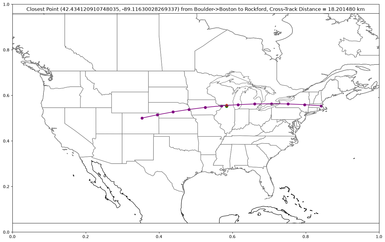
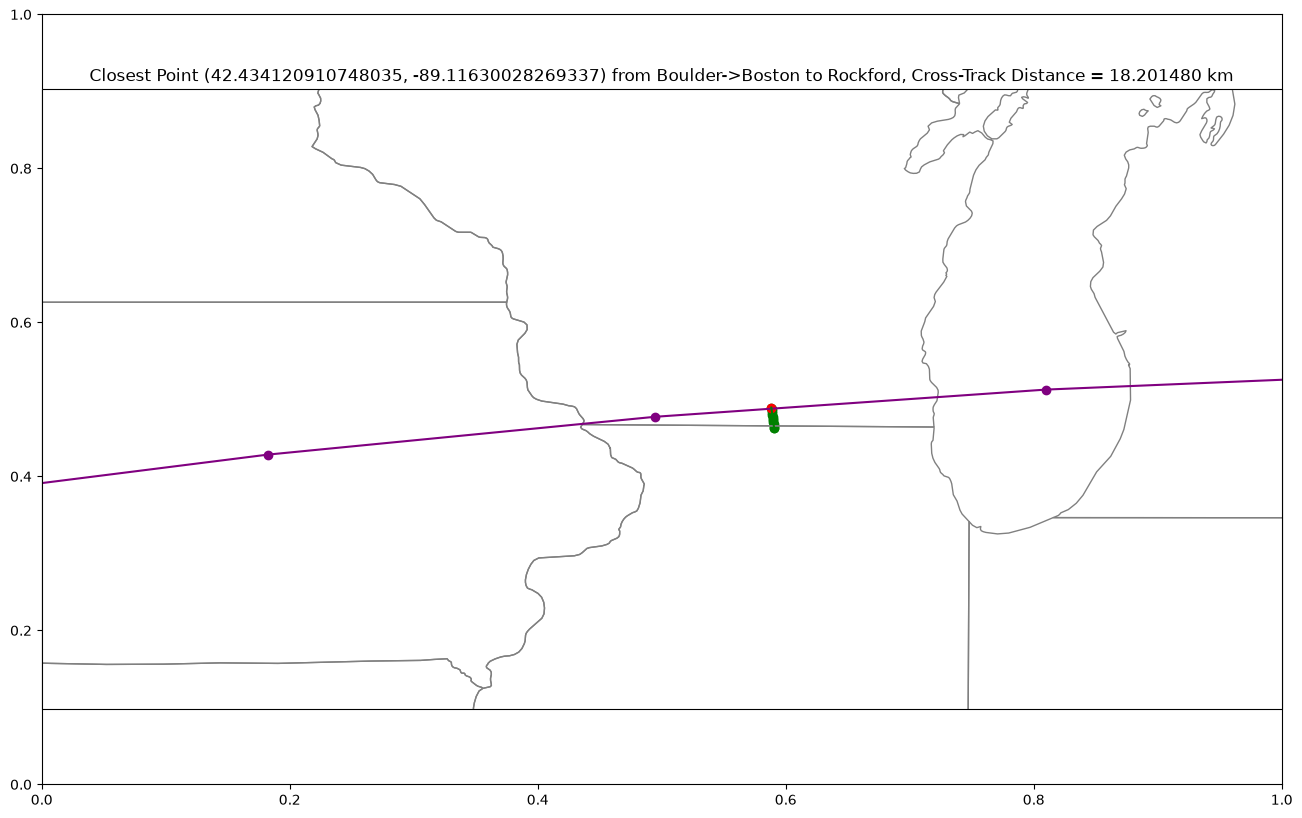
Hard to see, right? Let’s zoom in:
plot_cross_track(start_point="boulder", end_point="boston", new_point="rockford",
                 lon_west=-95, lon_east=-85,
                 lat_south=40, lat_north=45)
Cross Track Distance:
18201.48035911659 meters (18.20148035911659 km)
Along Track Distance:
1378654.5186233742 meters (1378.654518623374 km)
Closest Point To Point Along Great Circle Path:
(42.434120910748035, -89.11630028269337)
/home/runner/micromamba/envs/cookbook-gc/lib/python3.14/site-packages/cartopy/io/__init__.py:242: DownloadWarning: Downloading: https://naturalearth.s3.amazonaws.com/10m_physical/ne_10m_coastline.zip
  warnings.warn(f'Downloading: {url}', DownloadWarning)
/home/runner/micromamba/envs/cookbook-gc/lib/python3.14/site-packages/cartopy/io/__init__.py:242: DownloadWarning: Downloading: https://naturalearth.s3.amazonaws.com/10m_cultural/ne_10m_admin_0_boundary_lines_land.zip
  warnings.warn(f'Downloading: {url}', DownloadWarning)
/home/runner/micromamba/envs/cookbook-gc/lib/python3.14/site-packages/cartopy/io/__init__.py:242: DownloadWarning: Downloading: https://naturalearth.s3.amazonaws.com/10m_cultural/ne_10m_admin_1_states_provinces_lakes.zip
  warnings.warn(f'Downloading: {url}', DownloadWarning)
18 km is far, but for the sake of clarity, maybe it serves our purposes as “on the arc”. If so, we can increase the tolerance of the function to about 18 km to encompass the town:
# increase tolerance to capture point
print("tolerance = 0")
print(is_point_on_arc("boulder", "boston", "rockford", tolerance=0))
print("\ntolerance >= cross-track distance")
print(is_point_on_arc("boulder", "boston", "rockford", tolerance=18202))
tolerance = 0
Cross-Track Distance = 18201.48035911659 meters
False
tolerance >= cross-track distance
Cross-Track Distance = 18201.48035911659 meters
True
(Optional) Additional Python Package: UXarray
UXarray acts as an Xarray extension for unstructured data (commonly used in climate and weather analysis). This includes multiple functions for working with great circles:
uxarray.grid.intersections.gca_const_lat_intersection: Calculate the intersection point(s) of a Great Circle Arc (GCA) and a constant latitude line in a Cartesian coordinate systemgrid.arcs.point_within_gca: Check if a point lies on a given Great Circle Arc (GCA) interval, considering the smaller arc of the circle. Handles the anti-meridian case as welluxarray.grid.arcs.extreme_gca_latitude: Calculate the maximum or minimum latitude of a great circle arc defined by two 3D points
UXarray makes use of Cartesian coordinates and includes a very narrow built-in tolerance, but can be a simple solution if needed.
For example: Let’s check if a point lies on a great circle arc with UXarray (see example)
# Check if Boulder is on a great circle arc created by a point directly above (+latitude) and below (-latitude)

# Convert latitude and longitude points to Cartesian Points
def latlon_to_cart(lat, lon):
    from astropy.coordinates.representation import UnitSphericalRepresentation
    from astropy import units

    spherical_coords = UnitSphericalRepresentation(
        lat=lat * units.deg, lon=lon * units.deg
    )
    cart_coords = spherical_coords.to_cartesian()
    return np.array([cart_coords.x, cart_coords.y, cart_coords.z])


pt_within = latlon_to_cart(location_df.loc["boulder", "latitude"], location_df.loc["boulder", "longitude"]) # Boulder
vertex_a = latlon_to_cart(location_df.loc["boulder", "latitude"]+10, location_df.loc["boulder", "longitude"])  # Point exactly 10 degrees above Boulder
vertex_b = latlon_to_cart(location_df.loc["boulder", "latitude"]-10, location_df.loc["boulder", "longitude"])  # Point exactly 10 degrees below Boulder

# Determine if point lies along great circle arc
from uxarray.grid.arcs import point_within_gca

print(
    f"Boulder lies within the great circle arc = {point_within_gca(pt_within, vertex_a, vertex_b)}"
)Boulder lies within the great circle arc = True
Summary
In this notebook, we calculated and plotted the cross track and along track distance for points around a great circle arc
What’s next?
Next, we will determine when a great circle path crosses a given parallel and the maximum and minimum latitude coordinates of a great circle path.